Cafe nearby Kaffe
Sweden
Cafe nearby Kaffe
Kaffe
17, Sankt Paulsgatan, 118 46, Stockholm, SE Sweden
contacts phone
:
+46
Latitude:
59.3180528
, Longitude:
18.0673869
larger map & directions
read more
nearest Cafe
24 m
etc book café
Sankt Paulsgatan 14, Stockholm
Cafe
read more
31 m
ETC
Sankt Paulsgatan 14, Stockholm
Cafe
read more
109 m
Fru Bellman
Bellmansgatan 26, Stockholm
Cafe
read more
144 m
Nobba Brass och Nubbe
Björngårdsgatan 1B, Stockholm
Cafe
read more
171 m
Tårtan
Hornsgatan 32, Stockholm
Cafe
read more
200 m
Café En Halv Trappa Ner
Wollmar Yxkullsgatan 3, Stockholm
Cafe
read more
208 m
Hotel Rival
Mariatorget 3, Stockholm
Cafe
read more
232 m
Chic
Swedenborgsgatan 1, Stockholm
Cafe
read more
237 m
Fåtöljen
Götgatan 14, Stockholm
Cafe
read more
541 m
Rygerfjord
Söder Mälarstrand, Kajplats 13, Stockholm
Cafe
read more
594 m
Kransen's Konditori
Magnus Ladulåsgatan 61, Stockholm
Cafe
read more
752 m
Grändens Café
Yxsmedsgränd 2, Stockholm
Cafe
read more
797 m
Grillska Huset, Stockholms Stadsmission
Stortorget 3, Stockholm
Cafe
read more
896 m
Cafe 91
Folkungagatan 91, Stockholm
Cafe
read more
905 m
Kafé 44
Tjärhovsgatan 46, Stockholm
Cafe
read more
920 m
The Chocolate Factory
Renstiernas gata 12, Stockholm
Cafe
read more
1.247 km
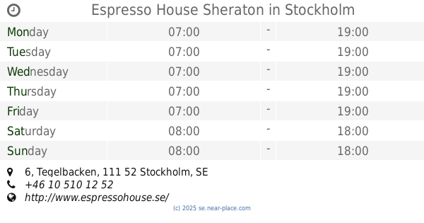
Espresso House Sheraton
Tegelbacken 6, Stockholm
Cafe
read more
1.266 km
Bagdad Café
Fredsgatan 2, Stockholm
Cafe
read more
1.467 km
Espresso House
Vasagatan 1, Stockholm
Cafe
read more
1.533 km
Upper Crust
Centralplan 15, Stockholm
Cafe
read more
1.676 km
KAFKAF
Hamngatan 10, Stockholm
Cafe
read more
1.676 km
JOE & THE JUICE
Hamngatan 10-13, Stockholm
Cafe
read more
1.82 km
Himalaya Kaffebar
Hötorgshallen 29 A, Stockholm
Cafe
read more
1.858 km
JOE & THE JUICE
Kungsgatan 57, Stockholm
Cafe
read more
1.923 km
McDonald's
Kungsgatan 50, Stockholm
Cafe
read more
📑
all categories
Accounting
Administrative area level 1
Administrative area level 2
Airport
Amusement park
Aquarium
Art gallery
Atm
Bakery
Bank
Bar
Beauty salon
Bicycle store
Book store
Bowling alley
Bus station
Cafe
Campground
Car dealer
Car rental
Car repair
Car wash
Casino
Cemetery
Church
City hall
Clothing store
Colloquial area
Convenience store
Courthouse
Dentist
Department store
Doctor
Electrician
Electronics store
Embassy
Finance
Fire station
Florist
Food
Funeral home
Furniture store
Gas station
General contractor
Grocery or supermarket
Gym
Hair care
Hardware store
Health
Hindu Temple
Home goods store
Hospital
Insurance agency
Jewelry store
Laundry
Lawyer
Library
Light rail station
Liquor store
Local government office
Locality
Locksmith
Lodging
Meal delivery
Meal takeaway
Mosque
Movie rental
Movie theater
Moving company
Museum
Natural feature
Neighborhood
Night club
Painter
Park
Parking
Pet store
Pharmacy
Physiotherapist
Place of worship
Plumber
Point of interest
Police
Political
Post office
Premise
Real estate agency
Restaurant
Roofing contractor
Route
Rv park, camping
School
Shoe store
Shopping mall
Spa
Stadium
Storage
Store
Subpremise
Subway station
Supermarket
Synagogue
Taxi stand
Train station
Transit station
Travel agency
University
Veterinary care
Zoo
sublocality level 1
sublocality level 2
↑