Cafe nearby Grändens Café
Sweden
Cafe nearby Grändens Café
Grändens Café
2, Yxsmedsgränd, 111 27, Stockholm, SE Sweden
contacts phone
:
+46 8 22 54 10
Latitude:
59.3247498
, Longitude:
18.0691982
larger map & directions
read more
nearest Cafe
530 m
Bagdad Café
Fredsgatan 2, Stockholm
Cafe
read more
587 m
Fåtöljen
Götgatan 14, Stockholm
Cafe
read more
608 m
Café Tegelbacken
Tegelbacken 4A, Stockholm
Cafe
read more
617 m
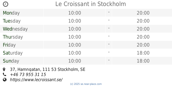
Le Croissant
Hamngatan 37, Stockholm
Cafe
read more
618 m
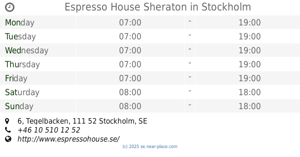
Espresso House Sheraton
Tegelbacken 6, Stockholm
Cafe
read more
619 m
Café Amanda AB
Drottninggatan 19, Stockholm
Cafe
read more
630 m
Espresso House
Drottninggatan 18, Stockholm
Cafe
read more
726 m
Cappuccio
Hamngatan 37, Stockholm
Cafe
read more
734 m
Fru Bellman
Bellmansgatan 26, Stockholm
Cafe
read more
747 m
etc book café
Sankt Paulsgatan 14, Stockholm
Cafe
read more
752 m
ETC
Sankt Paulsgatan 14, Stockholm
Cafe
read more
792 m
Hotel Rival
Mariatorget 3, Stockholm
Cafe
read more
864 m
Chic
Swedenborgsgatan 1, Stockholm
Cafe
read more
870 m
Espresso House
Vasagatan 1, Stockholm
Cafe
read more
881 m
Espresso House Stockholm Central
Centralplan 15, Stockholm
Cafe
read more
890 m
NK Konditoriet
Hamngatan 18-20, Stockholm
Cafe
read more
900 m
Espresso House
Hamngatan 18-20, Stockholm
Cafe
read more
905 m
Starbucks Klaraberg
Klarabergsgatan 39, Stockholm
Cafe
read more
924 m
KAFKAF
Hamngatan 10, Stockholm
Cafe
read more
924 m
JOE & THE JUICE
Hamngatan 10-13, Stockholm
Cafe
read more
935 m
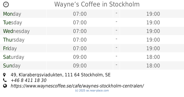
Wayne’s Coffee
Klarabergsviadukten 49, Stockholm
Cafe
read more
948 m
Upper Crust
Centralplan 15, Stockholm
Cafe
read more
1.04 km
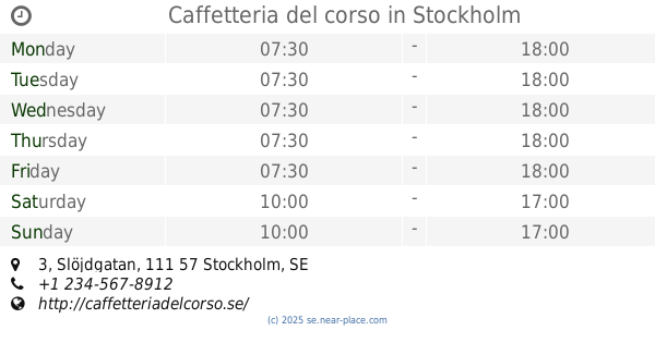
Caffetteria del corso
111 57, Slöjdgatan 3, Stockholm
Cafe
read more
1.246 km
Kafé 44
Tjärhovsgatan 46, Stockholm
Cafe
read more
1.28 km
Thelins Konditori
Kungsbron 4, Stockholm
Cafe
read more
📑
all categories
Accounting
Administrative area level 1
Administrative area level 2
Airport
Amusement park
Aquarium
Art gallery
Atm
Bakery
Bank
Bar
Beauty salon
Bicycle store
Book store
Bowling alley
Bus station
Cafe
Campground
Car dealer
Car rental
Car repair
Car wash
Casino
Cemetery
Church
City hall
Clothing store
Colloquial area
Convenience store
Courthouse
Dentist
Department store
Doctor
Electrician
Electronics store
Embassy
Finance
Fire station
Florist
Food
Funeral home
Furniture store
Gas station
General contractor
Grocery or supermarket
Gym
Hair care
Hardware store
Health
Hindu Temple
Home goods store
Hospital
Insurance agency
Jewelry store
Laundry
Lawyer
Library
Light rail station
Liquor store
Local government office
Locality
Locksmith
Lodging
Meal delivery
Meal takeaway
Mosque
Movie rental
Movie theater
Moving company
Museum
Natural feature
Neighborhood
Night club
Painter
Park
Parking
Pet store
Pharmacy
Physiotherapist
Place of worship
Plumber
Point of interest
Police
Political
Post office
Premise
Real estate agency
Restaurant
Roofing contractor
Route
Rv park, camping
School
Shoe store
Shopping mall
Spa
Stadium
Storage
Store
Subpremise
Subway station
Supermarket
Synagogue
Taxi stand
Train station
Transit station
Travel agency
University
Veterinary care
Zoo
sublocality level 1
sublocality level 2
↑