Bar nearby OSCHA Bar/Café
Sweden
Bar nearby OSCHA Bar/Café
OSCHA Bar/Café
15, Munkbron, 111 28, Stockholm, SE Schweden
contacts phone
:
+46 76 770 85 86
Latitude:
59.3243465
, Longitude:
18.0671591
larger map & directions
read more
nearest Bar
44 m
Tweed
Lilla Nygatan 5, Stockholm
Bar
read more
66 m
Tritonia Ölverkstad
Stora Nygatan 20A, Stockholm
Bar
read more
81 m
Barrels Burgers & Beer Gamla Stan
Stora Nygatan 20, Stockholm
Bar
read more
87 m
Wirströms Pub
Stora Nygatan 13, Stockholm
Bar
read more
87 m
Frank's Gourmet Hotdogs
Stora Nygatan 13, Stockholm
Bar
read more
114 m
Stampen
Stora Gråmunkegränd 7, Stockholm
Bar
read more
201 m
Celezte
Birger Jarls torg, Stockholm
Bar
read more
507 m
Akkurat
Hornsgatan 18, Stockholm
Bar
read more
541 m
Pickwick Restaurang & Pub
Drottninggatan 6, Stockholm
Bar
read more
603 m
Bistro Rolf de Maré
Drottninggatan 15, Stockholm
Bar
read more
622 m
Carousel
Gustav Adolfs torg 20, Stockholm
Bar
read more
640 m
Stockholm Wine Bar
Gustav Adolfs torg 16, Stockholm
Bar
read more
643 m
vodka bar
Regeringsgatan 3, Stockholm
Bar
read more
646 m
Vodka Baaren
Regeringsgatan 6, Stockholm
Bar
read more
691 m
Hamburger Börs
Jakobsgatan 6, Stockholm
Bar
read more
700 m
Restaurang M5 HB
Malmtorgsgatan 5, Stockholm
Bar
read more
844 m
Barcelona Tapas Bar
Drottninggatan 34, Stockholm
Bar
read more
940 m
SKYBAR
1, Vasagatan, Stockholm
Bar
read more
995 m
Laughing Duck
Vasagatan 7, Stockholm
Bar
read more
1.022 km
The Meat
Vasagatan 7, Stockholm
Bar
read more
1.026 km
The Bishops Arms
Vasagatan 7, Stockholm
Bar
read more
1.034 km
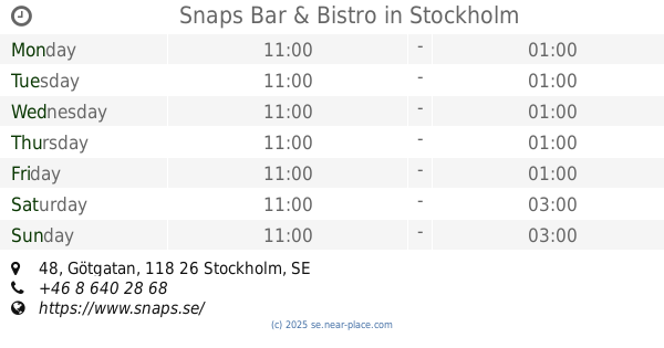
Snaps Bar & Bistro
Götgatan 48, Stockholm
Bar
read more
1.071 km
Belgobaren
Bryggargatan 12, Stockholm
Bar
read more
1.081 km
Nordic Light Hotel
Vasaplan 7, Stockholm
Bar
read more
1.184 km
NOFO Hotel & Wine Bar
Tjärhovsgatan 11, Stockholm
Bar
read more
📑
all categories
Accounting
Administrative area level 1
Administrative area level 2
Airport
Amusement park
Aquarium
Art gallery
Atm
Bakery
Bank
Bar
Beauty salon
Bicycle store
Book store
Bowling alley
Bus station
Cafe
Campground
Car dealer
Car rental
Car repair
Car wash
Casino
Cemetery
Church
City hall
Clothing store
Colloquial area
Convenience store
Courthouse
Dentist
Department store
Doctor
Electrician
Electronics store
Embassy
Finance
Fire station
Florist
Food
Funeral home
Furniture store
Gas station
General contractor
Grocery or supermarket
Gym
Hair care
Hardware store
Health
Hindu Temple
Home goods store
Hospital
Insurance agency
Jewelry store
Laundry
Lawyer
Library
Light rail station
Liquor store
Local government office
Locality
Locksmith
Lodging
Meal delivery
Meal takeaway
Mosque
Movie rental
Movie theater
Moving company
Museum
Natural feature
Neighborhood
Night club
Painter
Park
Parking
Pet store
Pharmacy
Physiotherapist
Place of worship
Plumber
Point of interest
Police
Political
Post office
Premise
Real estate agency
Restaurant
Roofing contractor
Route
Rv park, camping
School
Shoe store
Shopping mall
Spa
Stadium
Storage
Store
Subpremise
Subway station
Supermarket
Synagogue
Taxi stand
Train station
Transit station
Travel agency
University
Veterinary care
Zoo
sublocality level 1
sublocality level 2
↑